Chapter 01 of 09Ancient times to 1807
Before the deeds
Limestone laid down in an ancient sea, a creek that cut a hollow into the edge of the Highland Rim, and two Native nations whose claims ended with treaties in 1805 and 1806.
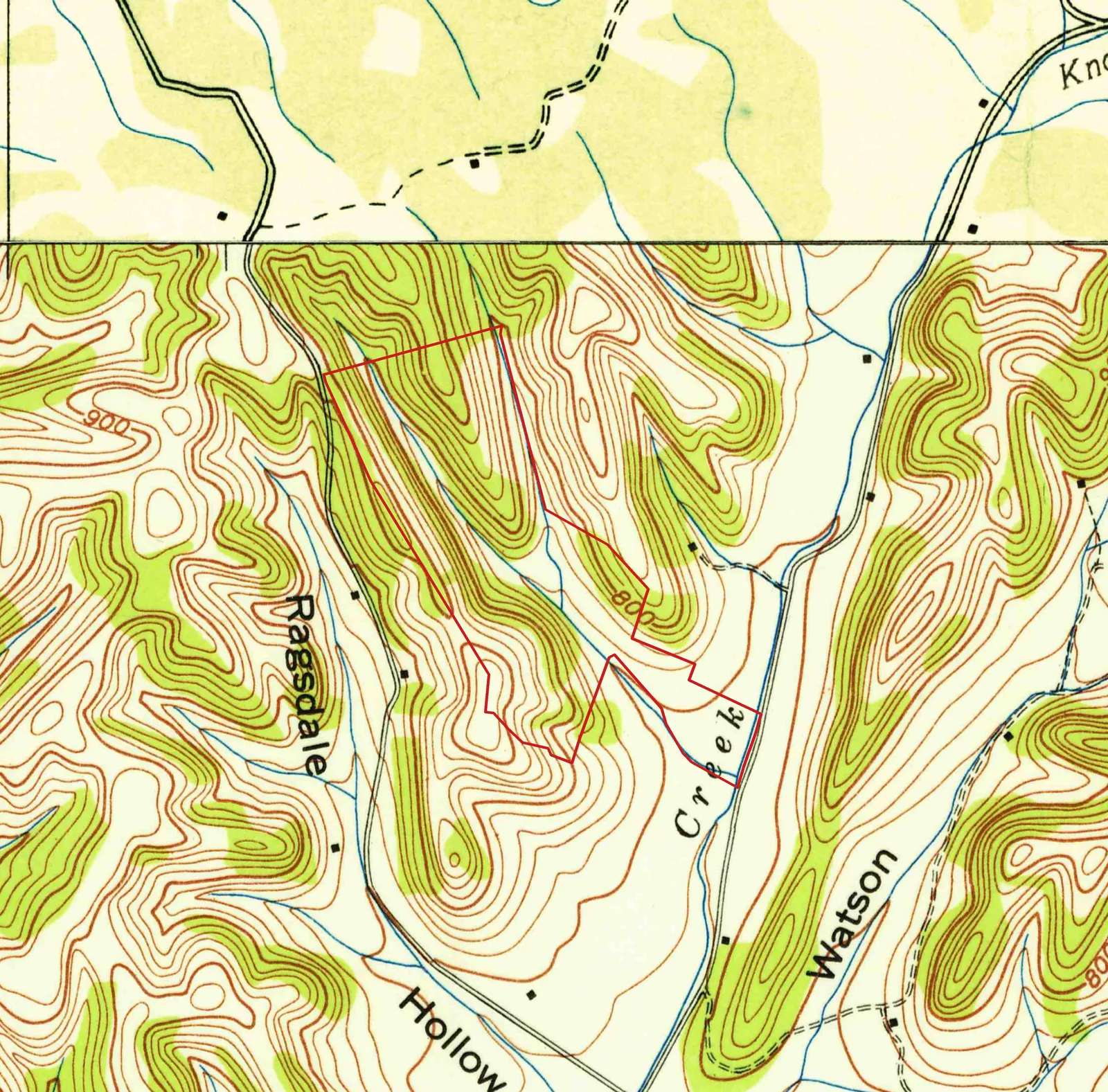
Godwin, Tenn. 7.5-minute quadrangle, 1940 edition (detail, parcel outline added). Tennessee Valley Authority / U.S. Geological Survey · USGS Historical Topographic Map Collection (topoView) · 1940 · Public domain (U.S. federal government work)
Long before there were deeds, there was rock. Stand in the hay field and the ground under your boots is limestone, laid down roughly 450 million years ago at the bottom of a warm, shallow sea. Geologists call these layers the Bigby-Cannon Limestone and the Hermitage Formation. They are full of the broken shells of creatures that lived and died in that sea.
The edge of the basin
Middle Tennessee is shaped like a shallow bowl. The Nashville Basin is the bottom of the bowl, a rolling country of limestone and rich soil around Nashville, Franklin and Columbia. The Highland Rim is the bowl's raised edge, a higher plateau capped by a harder, flinty rock called chert.
The farm sits right where the bowl's floor meets its rim. The hollow floor and the creek bottom are Basin limestone. Climb either ridge and you pass through younger Ordovician layers, and the highest knobs nearby are still capped with the chert of the Fort Payne Formation, the Rim's top layer. Over thousands of years, Knob Creek and its side streams have eaten back into the Rim, leaving fingers of high ground with narrow hollows between them. The hay strip runs up one of those hollows, from about 700 feet at the creek to about 800 feet at its head, with ridges near 900 feet on both sides.
Nobody knows for sure how Knob Creek got its name. A creek winding among knobby, chert-capped hills is a fair guess.
What the soil says
The soil survey maps eleven kinds of soil on the farm. About half the land is Bodine gravelly silt loam on slopes of 20 to 40 percent: the steep, stony ridgesides, full of chert fragments, best left in woods. Dellrose soils, worn and gravelly, sit on the lower slopes. The hollow floor is mostly Ocana gravelly silt loam, nearly level and occasionally flooded. That is the hay strip. Flat, deep and close to water, it is the one part of the farm that begs to be farmed, which helps explain why it has stayed open for at least ninety years.
One small patch of creek-bottom soil is mapped as Lindside cherty silt loam, "phosphatic phase." It is a hint of the mineral that would make Maury County famous.
Phosphate on Knob Creek
The limestone around Columbia carries phosphate, the raw material for fertilizer. According to the Tennessee Encyclopedia, a stonecutter named William Shirley found blue rock phosphate "around Knob Creek, north of Columbia" in 1891, and the first two tons were shipped the next year. That was the start of an industry that drove Maury County's economy for about a century. Whether Shirley's find was on this stretch of Knob Creek, or somewhere downstream, is not recorded. It was very likely the same creek.
Down to the Duck
Knob Creek starts in the hills just north of the farm. From the road it runs about seven or eight miles south-southwest and empties straight into the Duck River, west of Columbia. Its watershed covers about 10,800 acres.
The Duck is the longest river that lies entirely inside Tennessee, about 284 miles. It is one of the richest rivers in North America for life under water, with about 151 kinds of fish and 56 kinds of freshwater mussels. Every rain that falls on the hay field ends up there.
Before the treaties
People lived along the Duck River for thousands of years before any of this was written down. By the late 1700s, the land north of the Duck was hunting ground claimed by two nations: the Chickasaw to the west and south, and the Cherokee to the east. Both claimed the country between the Tennessee River and the ridge that divides it from the Cumberland.
White settlers wanted it. In a treaty signed July 23, 1805, the Chickasaw gave up their claim to a huge tract running up the Duck River and across Middle Tennessee. On January 7, 1806, in Washington, the Cherokee gave up their claim to the land north of the Tennessee River and west of a line to the head of the Duck. A note added in 1807 admitted that the two nations had both claimed this ground since 1794. Read against the treaty boundaries, the farm falls inside both cessions.
The Senate ratified both treaties in May 1807. Surveyors followed, and land warrants, some of them promised years before to North Carolina's Revolutionary War soldiers, were turned into acres. On November 16, 1807, the Tennessee General Assembly created Maury County. The first families were already arriving on Knob Creek.
- About 450 million years agoShallow tropical seas lay down the limestone under the hollow floor.
- About 350 million years agoCherty limestone forms on top. Its hard chert still caps the ridges.
- Thousands of yearsKnob Creek and its side streams cut the hollow down into the older rock.
- 1794 to 1805Both the Chickasaw and the Cherokee claim the land between the Tennessee River and the Cumberland ridge.
- 1805July 23: the Chickasaw give up their claim to a huge tract that includes Knob Creek.
- 1806January 7: the Cherokee give up theirs, in a treaty signed in Washington.
- 1807Both treaties are ratified in May. Maury County is created on November 16.